Free Shipping on orders over $500


Search Equipment & Guides
How to Calculate and Adjust a Benchmark Network
How to calculate and adjust a construction benchmark network. Covers differential leveling loops, closure error calculation, Bowditch adjustment, and benchmark documentation for vertical control.
How to Calculate Pipe Grade for Sewer Installation
How to calculate minimum pipe grade for sewer installation. Grade formulas, code minimums, and how to enter grade into Topcon TP-L6G and Spectra DG813 pipe lasers.
How to Calibrate a Rotary Laser Level: Field Check & Service Guide
How to check and calibrate a rotary laser level in the field. Two-peg test method for Topcon RL-H5A, Spectra LL500, Leica Rugby. When to send in for factory calibration.
How to Check and Verify GPS Accuracy on a Job Site
How to verify GPS rover accuracy on a construction job site. Check shot procedures, acceptable residuals, PDOP monitoring, and what to do when GPS accuracy fails.
How to Check Grade with a Laser Transmitter and Remote Receiver
Step-by-step guide to checking grade with a laser transmitter and remote receiver. Covers transmitter setup, receiver pairing, grade rod technique, HI calculation, cut and fill readings, and field documentation.
How to Check and Adjust the Level Vial on a Survey Instrument
How to check and adjust the circular and plate level vials on optical levels, theodolites, and total stations. Field adjustment procedure and when to send in for service.
How to Clean and Maintain a Total Station
Step-by-step guide to cleaning and maintaining a total station in the field and shop. Lens cleaning, axis checks, tribrach maintenance, and service interval recommendations for Topcon, Trimble, Leica, and Sokkia total stations.
How to Connect a GPS Receiver to a Machine Control System
Step-by-step guide to connecting a GPS receiver to a machine control system. Covers cable and Bluetooth connection, receiver configuration, correction link setup, and first-time system verification.
How to Document a Pile Driving Log for Foundation Work
Step-by-step guide to documenting a pile driving log for foundation work. Covers required log fields, blow count recording, driving criteria, refusal, and how to format logs for geotechnical review and structural sign-off.
How to Extend Battery Life on Survey Equipment in Cold Weather
How to maximize battery life on total stations, GPS rovers, and data collectors in cold weather. Storage, charging, field handling, and backup power strategies for Trimble, Topcon, Leica, and Spectra survey instruments.
How to Find Northing and Easting Coordinates on a Job Site
How to find northing and easting coordinates on a construction job site using a total station, GPS rover, or from plan sheets. Understanding State Plane coordinates, local systems, and coordinate display on Trimble, Topcon, and Leica equipment.
How to Interpret and Export Data from a Survey Data Collector
Guide to interpreting and exporting survey data from a field data collector. Covers point files, job structure, coordinate systems, raw observations, and export formats for Trimble, Topcon, and Leica.
How to Lay Out a Control Traverse on a Construction Site
Step-by-step guide to establishing a control traverse on a construction site using a total station. Traverse design, field measurement, closure check, and control hub placement for Topcon, Trimble, and Leica instruments.
How to Measure Building Setback with a Total Station
Step-by-step guide to measuring building setback with a total station. Covers control setup, property line identification, setback distance measurement, and documentation for permit and inspection compliance.
How to Perform a Collimation Check on a Digital Level
Step-by-step collimation check (two-peg test) for a digital level. Verify and correct line-of-sight error to maintain sub-millimeter elevation accuracy on construction and survey projects.
How to Perform RTK Initialization and Verify Fixed Solution
Step-by-step guide to RTK initialization for construction survey. Understand what Fixed vs Float means, how to force re-initialization, and how to verify your RTK solution before stakeout.
How to Perform a Two-Peg Test on an Optical Level
Step-by-step guide to the two-peg test for checking optical level collimation error. Setup, rod readings, calculation, and adjustment for Topcon AT-B4, Leica NA724, and Spectra precision levels.
How to Plumb a Column or Vertical Structure with a Total Station
Step-by-step guide to plumbing columns and vertical structures using a total station. Covers setup position, measuring face deviation, computing plumb error, and guiding ironworkers to correct column position.
How to Read a Survey Rod in Feet and Inches
How to read a Philadelphia rod, fiberglass grade rod, and direct elevation rod in feet and decimal feet. Understanding rod graduations, target settings, and converting decimal feet to inches for construction use.
How to Set Control Points with a Total Station
Step-by-step guide to setting construction control points with a total station. Covers traverse setup, angle and distance measurement, closure adjustment, monumenting, and network verification.
How to Set Elevation with a Water Level (Low-Tech Method)
Step-by-step guide to setting elevation with a water level. Covers hose preparation, reference marks, transferring elevation between points, and accuracy limitations of this low-tech leveling method.
How to Set a Floor Elevation Reference Point for Interior Work
Step-by-step guide to setting a floor elevation reference point for interior construction. Covers benchmark transfer from exterior control, wall marks, datum selection, and distributing elevation references to multiple trades.
How to Set Grade Stakes for Road Construction
Step-by-step guide to setting grade stakes for road construction. Covers reading design plans, computing cut/fill depths, setting centerline and offset stakes, and marking stakes for grading operators.
How to Set Grade with a Pipe Laser
Step-by-step guide to setting grade with a pipe laser for sewer and drainage installation. Elevation setup, grade entry, target reading, and accuracy verification for Topcon TP-L6G and Spectra pipe lasers.
How to Set Offset Stakes for Road and Utility Construction
How to set offset stakes for road and utility construction. Covers offset distance selection, slope stake calculation, marking conventions, and field procedures using total station or GPS.
How to Set Out Building Corners with a Total Station
Step-by-step guide to setting out building corners using a total station. Control setup, coordinate stakeout, batter board layout, and accuracy verification for Topcon GT, Trimble S-series, and Leica TS instruments.
How to Set Out Utility Alignment with a Total Station
Step-by-step guide to setting out utility alignment with a total station. Covers loading alignment data, staking pipe centerline, setting offset stakes, and verifying invert elevations.
How to Set Up Base and Rover RTK GPS for Construction
Complete workflow for setting up a base and rover RTK GPS system for construction. Covers base occupation, rover pairing, correction link, and field verification for Trimble, Topcon, and Leica.
How to Set Up a GPS Base Station for Construction
Step-by-step guide to setting up a GPS base station for RTK rover positioning: point setup, antenna height, correction format, and base verification.
How to Set Up Machine Control Grade on an Excavator
Machine control setup guide for excavators: GPS receiver mounting, sensor calibration, design file loading, and grade checking. For Topcon 3D-MC2 and Trimble GCS900 systems.
How to Set Up Machine Control on a Motor Grader
Step-by-step guide to setting up machine control on a motor grader. Covers antenna mounting, base station pairing, design surface loading, blade calibration, and pre-shift verification.
How to Set Up a Machine Control System on an Excavator
Step-by-step guide to setting up a machine control grade system on an excavator. Sensor installation, calibration, design file loading, and accuracy verification for Topcon X-53x, Trimble GCS900, and Leica iCON systems.
How to Set Up an RTK Base Station for Construction
Step-by-step guide to setting up an RTK GPS base station for construction surveys. Known point vs. autonomous setup, radio and cellular correction broadcast, and rover initialization for Trimble, Topcon, and Leica base stations.
How to Set Up the Spectra Precision LL500 Rotary Laser
Step-by-step setup guide for the Spectra Precision LL500 rotary laser. Tripod setup, receiver pairing, and grade work. Authorized Spectra dealer guide from Express Tools.
How to Set Up the Topcon RL-H5A Rotary Laser
Step-by-step setup guide for the Topcon RL-H5A rotary laser: tripod placement, leveling, receiver pairing, and grade work. From Express Tools — authorized Topcon dealer.
How to Set Up the Topcon TP-L6G Pipe Laser
Complete setup guide for the Topcon TP-L6G pipe laser: manhole setup, grade entry, target alignment, and common troubleshooting. Authorized Topcon dealer guide.
How to Set Up a Total Station on a Known Point
Step-by-step guide to occupying a known control point with a total station. Centering, leveling, backsight orientation, and residual checks for Topcon, Trimble, and Leica instruments.
How to Shoot Elevations with a Digital Level
Step-by-step guide to shooting elevations with a digital level. Setup, bar-code rod reading, HI method, data recording, and accuracy verification for Topcon DL-500, Leica Sprinter, and Trimble DiNi digital levels.
How to Stake a Drainage Swale for Grade and Alignment
Step-by-step guide to staking a drainage swale for grade and alignment. Covers centerline layout, flow line elevation staking, cross-section width staking, grade verification, and documentation for grading contractors.
How to Stake Out a Building Pad with a Total Station
Step-by-step guide to staking out a building pad with a total station. Covers instrument setup, design file loading, corner stakeout, grade stake offsets, and final pad verification.
How to Transfer Coordinates Between Job Files on a Data Collector
Step-by-step guide to transferring coordinates between job files on a data collector. Covers coordinate export, import methods, coordinate system matching, and verification for Trimble Access, Topcon Magnet, and Leica Captivate.
How to Transfer Elevation Across a Job Site with a Rotary Laser
Step-by-step guide to transferring elevation benchmarks across a construction site using a rotary laser. Backsight setup, height of instrument calculation, and elevation transfer for Topcon RL-H5A, Spectra LL500, and Leica Rugby.
How to Troubleshoot a GPS Rover That Won't Get a Fix
Step-by-step troubleshooting guide for GPS rovers stuck in float or autonomous mode. Satellite count, correction signal, multipath, and hardware checks for Trimble, Topcon, Leica, and Spectra GNSS rovers.
How to Troubleshoot a Rotary Laser That Stopped Rotating
Step-by-step troubleshooting guide for a rotary laser level that stopped rotating. Covers power issues, tilt sensor errors, mechanical failures, scan mode problems, and when to send for repair.
How to Troubleshoot an RTK Base Station Not Sending Corrections
Troubleshoot an RTK base station that is not sending corrections to rovers. Step-by-step diagnostic for UHF radio and cellular NTRIP correction broadcast problems.
How to Use a Rotary Laser Level: Step-by-Step Guide for Contractors
How to set up and use a rotary laser level for grading, concrete, and elevation work. Covers tripod setup, self-leveling, receiver use, grade checking, and calibration basics.
How to Use a Data Collector with a Total Station
Step-by-step guide to connecting and using a data collector with a total station for construction layout and survey. Bluetooth pairing, job setup, stakeout workflow for Trimble TSC7, Topcon FC-6000, and Leica CS20.
How to Use a Digital Level for Differential Leveling
Step-by-step guide to differential leveling with a digital level: rod readings, benchmark transfer, and closure check. For Leica, Topcon, and Sokkia digital levels.
How to Use a GPS Rover for Construction Stakeout
Step-by-step guide to GPS/GNSS rover stakeout for construction: base station setup, rover configuration, RTK initialization, and stakeout workflow. For Trimble, Topcon, and Leica rovers.
How to Use a GPS Rover for Construction Stakeout
Step-by-step guide to using a GPS/GNSS rover for construction stakeout. Point setup, RTK initialization, pole plumbing, and stakeout navigation for Trimble, Topcon, and Leica GNSS rovers.
How to Use a Level Rod Correctly with an Optical Level
Practical guide to using a level rod with an optical level. Covers rod types, plumb holding technique, reading the rod, computing elevations, and common errors that cause incorrect readings.
How to Use Machine Control on a Motor Grader
Motor grader machine control guide: reading the cab display, setting design surface, automatic blade control, and common operator errors to avoid.
How to Use Machine Control on an Excavator: Operator's Guide
Excavator machine control operator's guide: reading the cab display, bucket positioning, automatic dig mode, and grade verification for Topcon, Trimble, and Leica systems.
How to Use an Optical Level for Differential Leveling
Step-by-step guide to differential leveling with an optical level. HI method, turning points, closing the loop, and error tolerance for Topcon AT-B4, Leica NA724, and Spectra precision levels.
How to Use a Pipe Laser for Box Culvert Installation
Step-by-step guide to using a pipe laser for box culvert installation. Covers laser setup, setting grade and alignment, reading the target, and verifying invert elevations.
How to Use a Pipe Laser for CIPP (Cured-In-Place Pipe) Lining
How to use a pipe laser for CIPP lining operations. Covers laser setup, grade verification, inversion monitoring, and post-lining as-built documentation for sewer rehabilitation.
How to Use a Reflectorless Total Station for As-Built Survey
How to use a reflectorless total station for as-built survey. Covers EDM modes, targeting techniques, accuracy expectations, and documentation for construction as-builts.
How to Use a Rotary Laser for a Concrete Slab Pour
How to set up a rotary laser for concrete slab pours: laser placement, screed guide setup, elevation control, and verification. Step-by-step from Express Tools.
How to Use a Surveying Prism Correctly: Pole, Height, and Centering
Step-by-step guide to using a surveying prism correctly. Covers prism pole setup, height measurement, centering over a point, pole bubble leveling, and common errors that degrade total station accuracy.
How to Use a Total Station for As-Built Survey
Complete guide to using a total station for as-built survey. Covers instrument setup, control occupation, data collection strategy, and exporting deliverables for as-built documentation.
Free 14 days with every Express Tools purchase
Your equipment. Your data. All in one place.
Gradelog is the field-execution platform built for grading and earthwork crews. Log grade shots, track cut/fill, document phases with photos, and generate as-built reports — from the cab to the office.
- Grade shots & cut/fill tracking per job
- Photo documentation by phase, task, and equipment
- As-built reports ready for inspector sign-off
- AI field assistant — troubleshoot on the jobsite
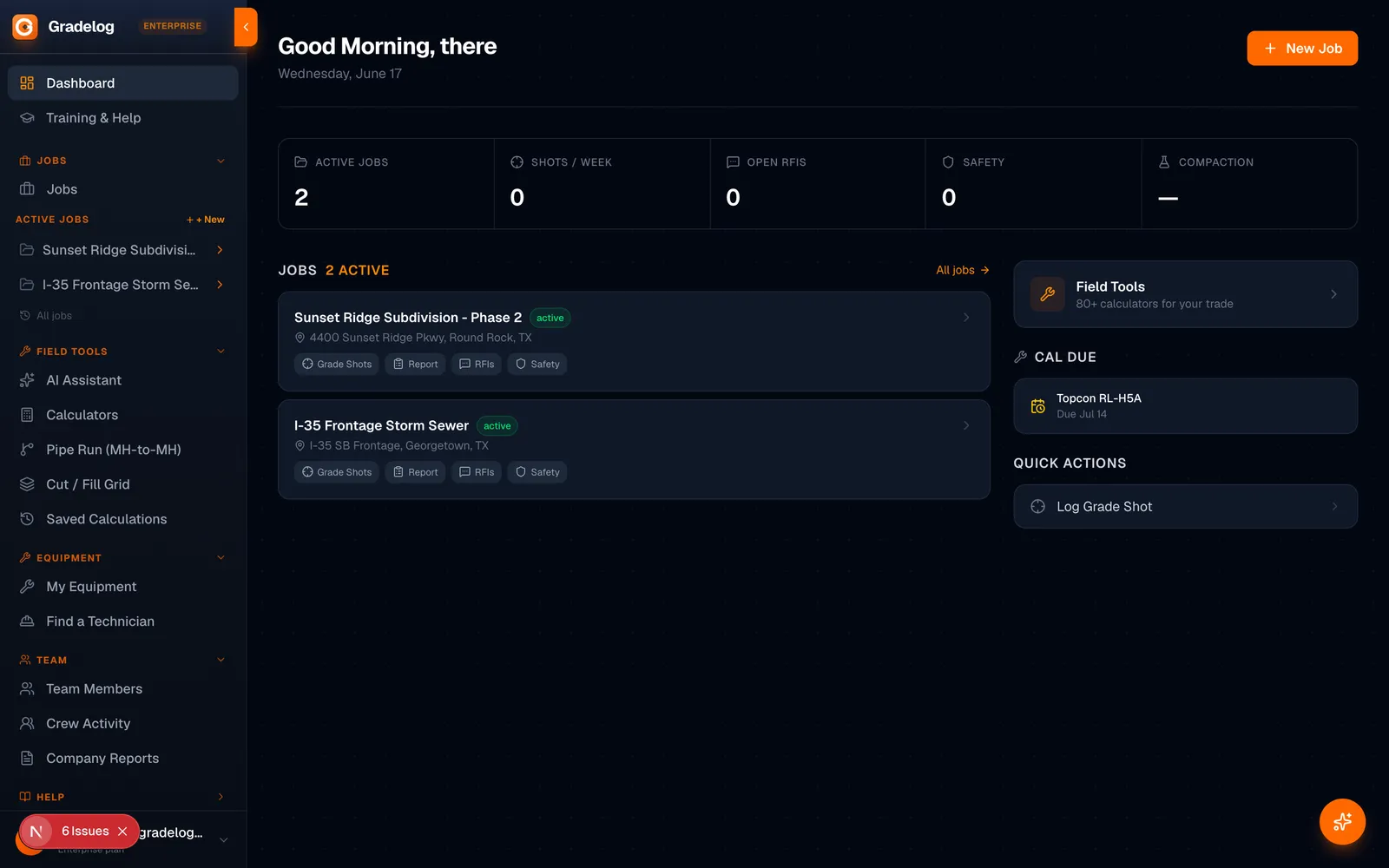
Built by the same team as Express Tools
Try Free →14 days
Free trial
8 languages
Supported
iPhone + Android
Works on